Russia quickly reacted to the Ever Given container ship blocking the Suez Canal and floated the idea that the maritime transport via this passage will be quickly replaced with the Northern Sea Route. However, this is a long way off and does not necessarily mean that Russians will actually start profiting from sea transport from Asia to Europe. Why? – Mariusz Marszałkowski, editor at BiznesAlert.pl, writes.
Russia’s reaction to the Suez Canal problems
Russians never miss an opportunity to comment on any negative event that is currently happening somewhere in the world. Especially if there is something they can gain from the situation. This has been very apparent during the pandemic, at the beginning of which they pursued the so-called „mask diplomacy”, which meant that they would send different kinds of medical equipment (often broken, incompatible with specification, without certificates) to various countries across the globe, and now they are taking similar steps with regard to the Russian Sputnik V vaccine. Such practices are always accompanied by an intensive misinformation campaign aimed at, among others, Russia’s competitors.
The incident at the Suez Canal has not gone unnoticed either, and is now being exploited by the Russian media and government agencies. The goal is to promote an alternative waterway to the Suez Canal, the so-called Northern Sea Route (NSR), also known as the North-East Passage.
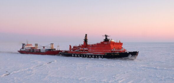
The examples include statements by the Ministry of Energy, statements made by the Minister of Energy himself, news disseminated by the TASS press agency controlled by the Russian government, or the state owned, Russian nuclear company Rosatom, whose daughter company Rosatomflot is the operator of the Northern Sea Route.
What is the Northern Sea Route?
The route runs from the Chukchi Peninsula (Provideniya harbor) to Murmansk. It goes across the Bering Sea, the Chukchi Sea, the East Siberian Sea, the Laptev Sea, the Kara Sea and the Barents Sea. It also passes through a few straits, including Bering, Sannikov and Kara. The NSR is a seasonal route, which means regular transport can take place there only for 8-10 months out of the year. In recent years this window has extended due to global warming (which is a lot more noticeable on the edges of the North Pole than in other areas of the planet).
Russians expect that by 2024 about 70 million tons of goods a year will go via that route, and in 2030 that figure will go up to 90 million tons, whereas in 2035 it will be 130 million tons. In 2020 as much as 32 million tons of cargo was transported via that route. It is estimated that the passage will be frequented more often not just by Russian vessels, but also by foreign ships. In 2024 foreign ships are to transport 1 million tons of cargo, in 2030 two and in 2035 as much as 10 million tons.
So far, the amount of cargo transported via that route is not astonishing. In 2020 foreign shipowners transported a little over 700 thousand tons of cargo via the route during 62 voyages. It was a significant increase in comparison to 2019, when only 37 ships with 500 thousand tons of cargo used the NSR.
To illustrate the scale and compare the two passages – in 2018 a little less than 19 thousand ships passed across the Suez Channel, they transported 1 billion 31 million tons of cargo.
Why the Northern Sea Route will not replace the Suez Channel?
Contrary to Russia’s expectations, the Northern Sea Route will not become a realistic alternative to the Suez Channel. However, geography and especially the length factor do favor the Russian way. The sea route between Tokio and Rotterdam via the Suez Canal is about 18200 km long. Whereas via the NSR it is only 11250 km long. Additionally the NSR is free from pirates. The area is almost uninhabited, and is the state border of Russia, which has been investing heavily in the militarization of the Arctic in recent years. Therefore, there is no risk that armed pirates would take over a ship. Unless, Russia as a state would be the pirate that takes over ships from states that do not have „friendly” relations with the Kremlin.
However, this is where the advantages of the North-East Passage end. The route’s main problem is its seasonality. As I mentioned earlier, the theoretical shipping season lasts on average around 8 months out of the year, but in practice the route is often available only between May and October. Despite the fact that this is the summer period a layer of ice often floats on the surface. In some areas, e.g. near the Kara Strait, icebreakers need to be on duty to break the ice to make the narrow passage passable.
In the autumn and spring ships need to be accompanied by Rosatomflot’s icebreakers. Of course this means the ship owners need to pay for this service, which increases the costs.
Apart from using the icebreakers, the vessels that sail through the route have to have the so-called „ice class”. This is a special class of ships that are capable of navigating through ice. This means their hull is strengthened well enough to not get damaged when going through floes floating on the water surface. Vessels used for LNG transport, or tankers that arrive at maritime oil loading terminals (e.g. Varandey) in the Arctic, are built to navigate beyond the polar circle. The majority of container ships that sail across the „warm” waters of the Pacific or the Indian Ocean to reach the Suez Canal do not have to have the ice class. The fleet of container ships and bulk carriers that do have this upgrade is not big, and they are usually owned by companies that operate in the northern hemisphere.
Additionally, because of the ice, despite the shorter distance, the navigation time is actually not proportionally shorter in comparison to the longer route via the Suez Canal. The average speed on this route is 14-17 knots. In case of the NSR it’s 6-8 knots. The reason being that the vessels need to go through ice and maneuver across numerous, dangerous navigation areas.
The NSR’s other problem is the permissible draught for vessels that operate on this route. In some places the water is too shallow for large container ships to pass. While ships whose draught is 21 meters can make it via, e.g. the Kara Strait, the Sannikov and Laptev Straits are passable only by vessels whose draught is less than 15 meters. Both passages are covered with ice all year long.
The Sannikov and Laptev Straits
Because of these bathymetric conditions only units with a payload of up to 5 thousand TEU (equivalent of 5 thousand, 20-foot, standard containers, used to determine the cargo capacity of container ships) can actually operate in the NSR. To compare, the payload of the most popular container ships of the Panamax class is between 5 and 12 thousand TEU. The payload of the biggest container ships, similar to the star of the incident at the Suez Canal – Ever Given, is between 18 and 22 thousand TEU.
The idea behind maritime transport is that the time of transport does not matter as much as the ability to load as much cargo as possible on a given ship. The more goods the container ship can hold, the smaller the shipping cost is. In case of NSR this economic factor loses its significance.
This impacts, among others, the cost of insuring the voyage. Due to the ice, bad weather conditions, the lack of necessary infrastructure and the potential risk of accidents, insurance for the crossing of the NSR is several percent higher than for similar transport across the „standard” route.
The NSR is also less attractive because of the lack of infrastructure and intermediate ports along the route. It is very rare that there are no intermediate stops between the origin and target harbors. Cargo ships usually stop on their way to unload or load cargo. This kind of ships is called feeder container vessels. There aren’t many container ports along the NSR. This and the navigational limitations make it impossible for container ships of the so-called Triple E class (biggest container ships in the world) with a draught over 16 meters), which are the most cost-efficient when it comes to direct voyages to hub ports, to travel across the NSR. Additionally, smaller vessels do not have access to ports along the route, where they could load or unload containers.
Another problem the vessels that travel along the NSR need to face is the temperature in the Arctic during the better part of the year. While for the transport of LNG (actually benefits from cold because of its state of matter), coal or oil temperature below -25-30 C (in the winter below -50C) is not a problem, for other goods such as electronics, food and „alive” goods, such temperature may be a significant problem.
Suez Canal will stay on top
The above factors, combined with the underdeveloped communication, rescue and port infrastructure make the NSR a lot less likely to become a true alternative to the Suez Canal. Especially that the channel is being modernized and in 2024 a new section will be opened, which will streamline the travel across the Canal even further.
The North-East Passage will undoubtedly remain an area that is of strategic interest to Russia. Over 90 percent of all the goods that are to cross the NSR in the future are natural resources such as gas, oil, coal, as well as iron ore, copper, timber and other minerals. Therefore, this route will be frequented very often.
However, this does not undermine Russia’s plan to build on this foundation another element of its rivalry with the West, and to show its importance on the international arena. Yet, the reality is a lot different, which is visible in the scale of both passages. In 2020 only 62 ships under a different flag that Russian passed the NSR. This number of vessels passes the Suez Canal in both ways on a single day. This is why the Northern Sea Route is not an alternative.