We still do not know who is behind the sabotage of the Nord Stream 1 and 2 gas pipelines. Investigations by both Swedish and Danish law enforcement agencies are ongoing, and Russia and Nord Stream AG are also looking into the matter. Will pictures from space bring us closer to the truth? BiznesAlert.pl received them from SpaceKnow – writes Mariusz Marszałkowski, editor at BiznesAlert.pl.
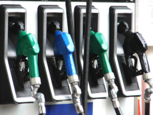
A technology company called SpaceKnow analyzed several hundred satellite images from 90 days before September 26, the day of the explosions on both pipes. After collecting the images, the company selected several areas, the smallest being 400 square meters large and located directly at the point where gas escaped from the damaged pipes, and then used computer algorithms to analyze their content. According to Wired, the photos revealed two vessels-ships (it was not specified), 95 to 130 meters long, which passed within a few nautical miles of the blast site. These vessels were operating with the AIS identification system disabled at sea and were therefore not visible to users of vessel tracking services. It’s been reported that these findings have been shared with NATO, which is also investigating the events.

Satellite image of gas escaping from the destroyed pipes. Picture by SpaceKnow.
But do the discoveries in the photos really have anything to do with the explosions of Nord Stream 1 and 2? Not necessarily.
The Automatic Identification System (AIS) shows the location of a ship or vessel in the water in real time. Vessels equipped with an AIS transponder transmit information about their position, speed, direction of travel, as well as the name, MMSI number and other data used for identification. The AIS was created to ensure the safety of navigation at a time when the traffic at seas and oceans has been skyrocketing. The AIS is also useful in and of itself, e.g. during rescue operations at sea.
In accordance with the fifth chapter of the SOLAS convention (International Convention for the Safety of Life at Sea), the AIS should be installed on all ships of gross tonnage (GT) 300, which are engaged in international navigation, all ships of GT 500, not engaged in international navigation and all passenger ships, regardless of their size.
As a general rule, ships should be equipped with an appropriate UKF transceiver (transponder) and an appropriate data processing and preparation computer. The devices can be connected to collision avoidance systems to provide maximum safety for both the crew and the ship. Thanks to the transponder, ships in the vicinity can see each other. The transmission range depends on, among others, how high the transponder is mounted on the ship (the higher the bigger the range) and on its capacity, as well as the weather. In general, the range of AIS varies between 10 and 30 nautical miles. Signals transmitted from the maritime unit are received by other ships in range and by AIS onshore stations. The AIS is used by popular portals that track ship traffic at sea, such as Marine Traffic and Vessel Finder.
Although the AIS is mandatory for most vessels, it is not always used. The crew decides whether the device should be turned on or not. In recent years, there has been frequent talk of „ghost armadas”, i.e. ships that deliberately do not make their positions available in order to carry out illegal activities, for example, to evade sanctions imposed on various states. The most striking example was the smuggling of Iranian oil to China. The oil from Iran has been sanctioned by the West. Iranian tankers turn off their transponders to transfer oil on the open sea, away from the shore and shipping lanes to tankers, which then head to the customer. Detecting and proving such a procedure is extremely difficult. In recent months, it has been observed that Russian oil tankers conduct similar missions. The vessels leave the Russian Baltic oil terminals, turn off the AIS signal in the waters of the Atlantic Ocean, where other ships are already waiting to take on board the prohibited cargo. After the transshipment, the ship carrying the oil or petroleum products from Russia goes back to the oil terminal, while the second unit returns to its own port. After a while, both units turn the transponders back on.
Experts from SpaceKnow claim that in the area where the Nord Stream pipes exploded in the Baltic they noticed two units 95 to 130 meters long. Neither of the ships (or vessels) had AIS transponders activated during the voyage. If they were warships, would that be out of the ordinary? Not necessarily.

According to the SOLAS convention, warships do not need to use the AIS. Of course, the ships themselves are equipped with it, but the crews are not obliged to broadcast theor positions. Different navies have their own rules for sharing positions within this system, e.g. the Polish Navy rarely shares a position through the AIS. Sometimes during some exercises or operations, for example, in the Bay of Gdańsk, the transponder is activated, but after the exit to the Baltic, the signal is turned off. The same applies to other fleets in the Baltic. Sweden and Denmark use their navies to patrol their territorial waters and exclusive economic zones.
The report from Wired does not include many details, as Piotr Stareńczak, a maritime journalist, points out. „We don’t know exactly what the outcome of the SpaceKnow investigation is. What has been leaked to the media is very laconic and unconvincing. We do not know, for example, whether the units observed in the vicinity of Bornholm are „civilian” ships or naval vessels. It is also not known how they behaved, whether, for example, they maneuvered unusually or stayed in the area for a long time. It is possible that the full report contains much more valuable information and it may be useful for the investigation,” Stareńczak told BiznesAlert.pl in an interview.
The journalist also pointed to another important element. „In the area of Bornholm, along the main shipping routes, but not only, 60 thousand units sail annually. The passage of these two vessels in this area does not have to mean something unusual,” he explained.
Stareńczak did not rule out that these units may be military vessels. „Warships have no obligation to use the AIS. Of course, in recent years this has been happening more and more often. Navies often use civilian solutions to maintain navigation safety, also utilize more environmentally friendly propulsion systems to reduce greenhouse gas emissions or harmful substances, or have historically been certified as „civilian” by classification societies. However, the absence of an AIS signal, even in the case of a merchant ship, not just a vessel, does not necessarily, always and unequivocally suggest something that would indicate illegal activity,” said the expert.
Do we know more or less?
From the information we have, we know that the authors of the report focused on explosions in the Danish economic zone, southeast of Bornholm. Over the course of 90 days, at least a dozen ships and ships belonging to different countries sailed directly over the site of the explosion. Based on the photos, however, it is not certain whether any of these units are responsible for the possible sabotage. It is worth remembering that there are many hypotheses regarding the explosion, including suggestions that an explosive device was injected into the pipes via a special piston that is usually used to clean and monitor pipes from the inside (such a piston is injected directly into the pipe at the compressor station). Another theory says that they had been placed during the construction of the pipe (which in my opinion is the least likely option), or that they had been placed at the beginning of the war with Ukraine, which would be way before SpaceKnow’s investigation timeline.

However, it is worth emphasizing that a large naval unit is not needed to place the explosives, especially that it would have been noticed by many, including fishermen, explorers and yacht owners. In any case, such a unit would not have to stay in the vicinity of the gas pipelines. The range of underwater bathyscaphes and remote-controlled devices is far enough that such a ship or vessel could be at a considerable distance from the explosion sites to carry out its mission without suspicion. So what are the two mysterious entities?
Most likely, these are ships belonging to the Danish navy, which performed routine patrols of its waters. Is it possible that their AIS was off? Yes, this is actually often the case. It is therefore too early to draw too far-reaching conclusions from this data.